Here are a selection of our recent and ongoing projects:
Sedimentary and oceanographic controls on hazards in the Northwestern Pacific Ocean
Sponsor: Royal Society (2023-2025)
PI: Uisdean Nicholson; Co-Is: Dorrik Stow, Amy Gough. Debora Duarte. Project Partners: Nao Nishida (Tokyo Gakugei University), Takuya Itaki, Kazuhiko Fuita (AIST, Japan
Summary: Contourites are muddy or sandy sediments that form under the influence of strong bottom currents in the ocean. These bottom currents mainly occur because of the so-called ‘thermohaline circulation’ system, where temperature and salinity (and thus density) contrasts, drive convection in the ocean. This acts like a conveyor belt, with cold, dense water sinking at the poles, and warm water upwelling at lower latitudes. In the Atlantic, this conveyor belt is known as the ‘Atlantic Meridional Overturning Circulation’, or AMOC, and is a crucial part of the climate system. The contourite drifts that form near these currents contain important records of how these currents have changed through time. They are also recognised to be unstable, as they are often deposited on relatively high-angle continental slopes, and also contain weak layers that are prone to failure. In many places around the Atlantic in particular, these drifts are recognised to have failed many times in the past, forming large underwater landslides that could represent important tsunami hazards.
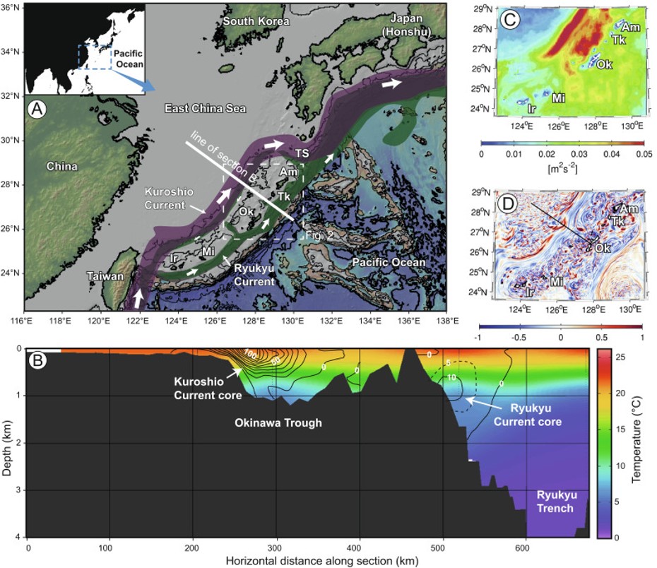
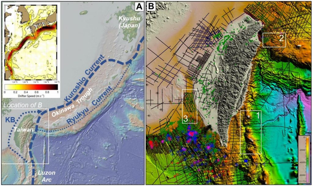
This thermohaline circulation system is much weaker in the Pacific ocean, and thus this area has not been extensively studied by the oceanographic or geohazard community. However, recent work led by the Japanese team have identified a very extensive contourite system that formed under the influence of the Kuroshio Current – a strong, wind-driven surface current – offshore Japan. This research proposal aims to
extend that work to understand the influence of this current on slope stability, and tsunami hazards, on the Japanese continental slope.
Figure below: Kuroshio current location and dynamics (Nishida et al., 2022; see publications page).
Sedimentary Controls On Megathrust Earthquake Mechanisms
Sponsor: NERC Moratorium Grant (2024-2026)
PI: Uisdean Nicholson; Co-Is: Amy Gough, Alexis Cartwright-Taylor, Nathaniel Forbes-Inskip (HWU Geoenergy group)
Summary: Megathrust earthquakes and associated tsunamis are one of the most important geohazards that affect human populations. The M9.0 Tohoku earthquake offshore Japan was one of the largest
earthquakes of the last century and resulted in over 20,000 fatalities and around $235 billion in economic damage (World Bank estimate). The majority of the damage was caused by the tsunami, which locally exceeded 40 m in height, overwhelming tsunami defence systems in Japan. This tsunami was generated because of the exceptionally shallow slip of the plate-bounding fault, which propagated to the surface near the Japan Trench. The surface rupture and uplift near the fault, resulted in over 10 m vertical and 50 m lateral motion (Fujiwara et al., 2011). This shallow slip and surface movement demonstrated that the shallow portions of megathrust faults do not always behave aseismically. In the case of the Tohoku earthquake, it appears that the physical properties of the subducting sediments, particularly smectite-rich shales with low shear strength (Chester et al., 2013), may have contributed to the shallow slip and increased tsunami magnitude from this event.
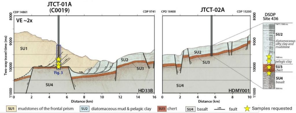
IODP Expedition 405 aims to characterize the physical properties (composition, structural characteristics and frictional properties) of the sediments within the accretionary prism and around the fault zone (site JTCT-01A), as well as the undisturbed sediments entering the subduction zone (site JTCT-02A) (below). This expedition will also constrain fluid pressure changes in the fault zone through the installation of a borehole observatory in site -01A. This will allow us to address fundamental questions about the role of sedimentological and physical properties, and shallow fluids, in controlling earthquake slip and associated tsunami hazards.
Figure below: JTrack samples being analysed for this project (adapted from JTrack prospectus).
Sponsor: Petronas (2022-2025)
PI: Uisdean Nicholson; Co-Is: Florian Doster, Andreas Busch; PDRAs: Iain de Jonge-Anderson, Hariharan Ramachandran; PhD student: Ana Widyanita.
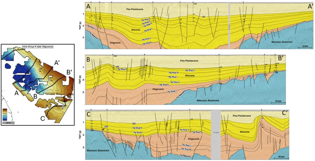
Summary: Carbon capture and storage (CCS) in saline aquifers is necessary to reach Net Zero emissions targets in the coming decades. The Malay Basin offshore Malaysia is one of the most important storage sites in SE Asia, but the storage capacity of regional aquifers and efficacy of seals is uncertain. In close collaboration with the HWU Geoenergy group and MuPhi group, this project integrates regional 3D seismic reflection data, well data, experimental work to characterise caprock facies, porosity, permeability, capillary entry pressures, together with Vertical Equilibrium (VE) modelling to understand the CCS potential of this basin.
Figure below: Regional seismic cross sections from the Malay Basin (de Jonge Anderson et al., 2024)
Sponsor: NERC (2022-2024)
PI: Uisdean Nicholson; Co-Is: Dorrik Stow, Andrew Tien-Shun Lin (NCU, Taiwan), Elda Miramontes (Bremen, Germany; PDRA: Debora Duarte.
Summary: The global ‘conveyor belt’ of ocean currents are an important part of Earth’s climate system, transporting heat and nutrients around the global oceans. They also transport large volumes of sediments and re-deposit these in large drifts in the deep oceans. These sediments then provide an important archive of the current systems that produced them, as well as changing temperatures and environmental conditions. In recent years, we have increasingly recognized that the large-scale eddies in the Earth’s large surface currents, such as the Gulf Stream, also play an important role in the deep ocean. These eddies, which are equivalent to cyclones in the atmosphere, are concentrated at ocean fronts, and can cause deep erosion of the seabed – many hundreds of metres deep in some cases.
The Kuroshio Current is one of these important surface current systems (associated with a front), that is a fundamental part of the ocean circulation system of the Pacific. Our recent work to the south of Taiwan, and offshore Japan, shows that this is a highly dynamic system which interacts with the complex seabed at an active margin (where two tectonic plates are colliding), deeply eroding and re-distributing sediment. In this project, we ause seismic reflection data, multibeam bathymetry data (proving high-resolution seabed maps) and core samples, to understand the impact of the Kuroshio Current. We specifically test how the current interacts with elevated tectonic ridges and whether it is capable of eroding deep channels across the continental shelf and slope.
Figure below: Datasets offshore Taiwan being used for this project
Beyond the Nadir: Early Cretaceous-Cenozoic archives of the northern Equatorial Atlantic Gateway
Sponsor: NERC (2022-2024)
PI: Uisdean Nicholson; Co-Is: Dorrik Stow, Andrew Tien-Shun Lin (NCU, Taiwan), Elda Miramontes (Bremen, Germany; PDRA: Debora Duarte.
Summary: This proposal seeks to build a stratigraphic framework from seismic reflection data to prepare for a future ocean drilling proposal in West Africa. This drilling proposal will aim to understand (1) the timing of separation of South America and Africa, forming the ‘Equatorial Atlantic Gateway’ when the ocean basins of the North Atlantic and South Atlantic were connected for the first time; (2) ocean conditions (temperature, chemistry, oxygen content) during extreme warm periods in Earth history; and (3) to understand the environmental consequences of a potential meteorite impact ~65 million years ago.
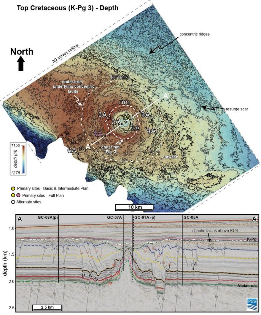
The final aim of this project is to further develop an IODP proposal (1004-APL) to understand the consequences of a meteorite impact at the end of the Cretaceous period. The Nadir Crater formed at approximately the same time as the dinosaur-killing Chicxulub Crater in Mexico and may be related to that event. The crater has been identified on 2D seismic data but newly acquired 3D data will illuminate the crater morphology and character much more clearly, allowing us to build more robust models of the environmental consequences of this event (landslides, ejecta, tsunamis). This will also highlight alternative (for proposal 1004-APL) or additional (for the new proposal) drill sites to test the impact crater hypothesis and understand its consequences. Drilling the crater will be necessary to test whether this feature was indeed formed by an impact crater and, if so, the precise age of the crater. This will allow us to date it precisely and to test whether the Chicxulub event was actually a binary system (two asteroids) or part of a longer lived ‘impact cluster’ over a course of hundreds of thousands or several million years.
Figure below: Proposed drilling sites for IODP proposal 1004, adapted from Nicholson et al., 2024.